Categories
Blog

Nicholson River Landcare share strategies with FoGL

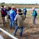
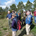
On Saturday May 4th, Nicholson River Landcare hosted 10 members of Friends of the Gippsland Lakes Parks and Reserves on walks on the properties of Leo Rijs and Jim Stephenson. The work of carbon trading company Citola in planting 50000 trees using the “rip and mound” method on the Rijs property was highlighted.

The President of FOGL_logo_parksandreserves_w150FOGL, Wendy Parker, gave a talk to the combined group on the current projects and challenges of her group. This was followed by another great lunch provided by Marcia Rijs and helpers. After lunch the group drove down the road to Jim Stephenson’s property where Jim led a tour highlighting the extensive revegetation works adjacent to the mouth of the Nicholson River. The day concluded with coffee and cake at the Stephenson homestead.

Peter Wallace

Publicity Officer

Nicholson River Landcare

Categories
Blog

Sea spurge – an invasive threat in the Gippsland Lakes Coastal Park

Sea Spurge

Sea spurge, Euphorbia paralias, is an invasive beach weed that originated from Europe. Sea spurge was probably introduced to Australia in ships’ ballast water about 70 years ago. The plant first appeared in Western Australia and is now found throughout south-eastern Australia, including Tasmania and the islands of Bass Strait. The weed is now in the Gippsland Lakes Coastal Park.

Sea spurge is a problem because each plant can produce up to 5000 salt-tolerant seeds. These seeds can survive for a number of years on ocean currents that spread them from beach to beach. Once established, a sea spurge colony can spread rapidly, displacing the native vegetation and changing the structure of the beach. This can disrupt many native species including the endangered shorebirds (hooded plovers, little terns and oystercatchers) that use open sand spits for nesting.

Sea spurge can grow anywhere on the beach front, from the high water mark to well into the dunes, and has also been found on rocky foreshores and rock shelves, on the steep back dunes and inside the mouths of coastal lakes and estuaries. It has now been observed at a number of locations inside the Gippsland Lakes, as well as along the coastal side of the Lakes.


Friends of the Parks and Reserves of the Gippsland Lakes (FoGL), in partnership with Parks Victoria (PV), is undertaking a weeding program at a number of locations within the Coastal Park. The first of these was held at Barrier Landing and Rigby Island on November 20th. Six  FoGL members and three PV staff removed the weed from both sides of the coastal track at Barrier Landing, as well as along the lake shore. They were also able to clear a more remote area on Rigby Island.

Follow up weeding at these sites is planned for the autumn and it is hoped that regular twice yearly maintenance will keep Sea spurge under control, so that it does not become a problem weed in the Park.

View Gallery

Categories
Blog

FoGL’s annual Boole Poole monitoring project

growth outside vs inside tree guard

growth inside tree guard

FoGL’s concern that introduced browsers, namely Hog Deer, have a negative impact on biodiversity in the Gippsland Lakes Coastal Park has led to an annual monitoring project to record species and recruitment, survivability and growth rates of native plant species on Boole Poole.
Assistance has been provided by Bruce Macpherson, Conservation and Land Management, Forestec who has created the methodology and James Turner, renowned local botanist and FoGL member who has identified the species existing in the survey areas.

Go »here to read their reports for which FoGL are very grateful.

Thanks also to Parks Victoria for their assistance.
What is significant is the degree to which browsing has inhibited growth of seedlings and what species are missing entirely which normally would be expected to exist in the survey areas.

Categories
Blog

Spring comes to Macleod Morass

Friends of the Parks and Reserves of the Gippsland Lakes (FoGL) held a very well attended Springtime walk at Macleod Morass on Saturday October 13th. After the rejuvenation of Winter and Spring, the Morass is a hive of activity.
This 520 hectare fresh water marsh is part of a worldwide scheme to protect and enhance wetland habitat. Spring is probably the best time of year to appreciate the breadth of its wildlife.
The walk through the Morass was led by Jim Reside of Wildlife Unlimited, a professional environmental consultancy based in Bairnsdale which works internationally as well as throughout Australia.
The Morass has been under threat by the rampant growth of Cumbungi, which has made it difficult for birds to move through and nest. Birdlife EAST Gippsland has previously recorded 155 species in this area. Bairnsdale’s Head Ranger Jeremy Tscharke described how Parks Victoria had approached the management of this important area which is subject to the conditions of the Environmental Protection and Biodiversity Conservation (EPBC) Act.

Categories
Blog Events

Burnt Bridge Guided Night Walk

The Friends of the Parks & Reserves of the Gippsland Lakes (FoGL) in association with Parks Victoria invite the community to a summer spotlight night walk to observe nocturnal animals in the wild.

The activity will be held at Burnt Bridge in the Lake Tyers Forest Park located on the Princes Highway 11 Kilometres east of Lakes Entrance.

A spotlight walk at this time of the year provides an excellent opportunity to observe active animals in the trees and seeking food in the water of Toorloo Arm.

Please note that this activity involves walking on bush tracks in the dark and is not recommended for children under 8 years old.

Guides will be;

  • local experienced environmentalists Jim Reside and Rohan Bilney of Wildlife Unlimited, with assistance from Parks Victoria Rangers.

As the night walk is very popular the number of participants will be restricted so if you wish to attend you are asked to register your interest. (president@fogl.org.au – 5156 2175)

If people would like to have a picnic tea (byo) before the walk, please allow enough time as it is important to have a punctual start once it is dark around 8.45 p.m.

You may also like to bring a snack and drink to have before the start or at the end of the walk.

Participants should wear suitable clothing and bring insect repellent, picnic tea/supper, binoculars, and torch (Guides will carry spotlights for observations).

Directions – Travel approximately 9kms east from Lakes Entrance to the Burnt Bridge turnoff on right, the east side of the highway. Follow the road approximately 1 kilometre to the Burnt Bridge Picnic area on Toorloo Arm, refer to map below (green arrows points to Burnt Bridge) –

View Larger Map
Parks Vic MAP

Categories
Announcements Blog Blogroll

Macleod Morass Canoe Paddle Friday 11 November

Parks Victoria Ranger in Charge of the Bairnsdale area Jeremy Tscharke expressed how pleased he was with the turn out, and was amazed by the knowledge and enthusiasm of the guide Jim Reside. The Macleod Morass is an exciting and diverse freshwater environment. Community field trips such as this one help the public to better understand the values that Parks Victoria work to preserve.

Categories
Blog Blogroll Events

FoGL Macleod Morass Planting Sat 8th October

Prep site 27th August
Planting 8th October
(bbq on Planting Day 1230-1315)

Thanks to Coastcare Victoria (for the funding) and Parks Victoria (for the invaluable assistance), FoGL planted a 3000 sqm area alongside Macleod Morass on Saturday 8th October.
Our hard-working members who did attend got the site planted out and Hughy rewarded our hard slog with a follow-up rain the next day.
Thanks Rob and Jeremy (Parks Victoria), Richard Vuat (Wildseed), Cinnamon, Connor and Torin (all from Bairnsdale Scouts), Jim Reside (Wildlife Unlimited) and Trevor, Nancy, Geoff, Wendy, Bill C, Bill B, Margaret, Anne, Gayle, Jenny, David, Maurice (all from FoGL).

View FoGL MM Planting Area in a larger map

alongside Saleyards Rd. looking north

alongside Saleyards Rd. looking south